
The kind of close relations India has shared with Nepal historically, has not been shared with any other country. Indian and Nepalese cross the border without a visa and can reside and exertion without any balk. India and Nepal’s long-suffering border tensions have repeatedly aroused nationalist movements and demurral in Nepal and isolated Nepal from India.
During few years the relations between the two countries became complicated. Prime Minister of Nepal claimed that India is responsible to spread coronavirus in Nepal. Furthermore, PM also accused that India is occupying some areas of Nepal.
Read More: Pakistan Turkey Strategic Alliance
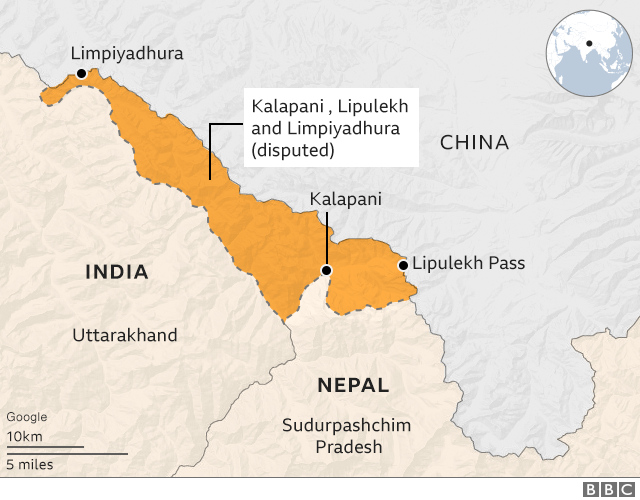
After two events of controversy started between the two.1st was in November 2019 Nepali government strongly offended when the Indian government releases a map and the region Kala Pani was included in its new map. And 2nd controversy was on 8th May 2020 when India’s Defence Minister inaugurates a new road (80 km) that came along the India-Nepal border and cross the disputed area and reach the Lipu Lekh.
This road was constructed for Kailash Mansarovar Yatris. After the inauguration of this lake, the Nepali government was offended because of their belief that Lipu Lekh is under the control of Nepal as this piece is their legal right. Nepal said India should have consulted before constructing a road. In this regard, Nepal protests against India over constructing roads passing through the disputed border area Lipulekh pass.
India’s ministry of external affairs said in this response that the area and road along the Nepal border fall within the Indian Territory that’s why the Indian government did not discuss it with the Nepali government. The region is of strategic importance, and the new road is now one of the fastest connections between Delhi and the Tibetan plateau.
On 15th May 2020 Army Chief of India asked that the protest in Nepal is due to the hand of a third party (China), Nepali became offended when they heard the stitchery stance of India.
In the 1800s when the British control over the subcontinent, Britishers try to expand over the Nepali kingdom (Gorkha).
Anglo Nepalese War started from (1814-1816) between the Gorkha Kingdom and the British. Then a treaty was signed called the Treaty of Sugauli. In this treaty, they decided that how much area is controlled or divided between the two countries. According to the Treaty of Sugauli, Nepal loses Sikkim and Darjeeling areas and now Britishers gain this area.
Due to the wide stream, British Raj define the west river stream, the border, and Nepal gained the extra region. And in the 1860s, Britishers changes the map smartly and shows the boundary according to the East river stream and it has been considered the border from the 1860s to 1947. India has been ineffective ownership of this territory for at least sixty years.
There was a monarchy in Nepal that’s why Monarch had no problem with this unofficial border. The border dispute was first started in the 1990s when democracy prevailed in Nepal. And Nepali people demanded to return this area and considered it as a disputed territory.
In July 2000, they tried to solve the border dispute but in no vain. Because India refuses to remove the Indian army from that area. In May 2015, India and China decided to use Lipulekh for trade and this was the point where the relations of both countries became worsen. Nepal objects to the India-China trade pact via the Lipulekh pass.
Indian and Nepali governments agreed during Modi’s 2014 visit to discuss the issue through Foreign Secretary-level talks. Nepal recounted that it tried twice to persuade such talks since then, and received no positive response from Delhi. In December, there was also news interspersed that India brushing the issue under carpet, even purportedly denying to receive a delegate to discuss the dispute. India put a stop to this matter from their side and this creating natural uneasiness in Kathmandu and will cause bilateral relations.
Lastly, if viewed geographically then Nepal is Right according to the Sugauli Treaty which tells that the western boundary of Nepal would be defined according to the Mahakali river. So, it is crystal clear that when the river divides, the Western River is the bigger one and it should be used as a boundary and according to this logic Nepal is right. But if we study this region historically and practically India is right because the British have been using it as a boundary since the 1860s. And if the monarchs of Nepal did not have any issue with this unofficial border that was in use for many years then why now have Nepali demanded to return their old border so it does not make any sense.
On the other hand, the Indian government should talk friendly about the construction of the road. So maybe, the agreement could be reached together and as many tensions would not prevail between India and Nepal.
Author:
Sania Sajjad is an undergraduate student of Department of International Relations at International Islamic University, Islamabad.